
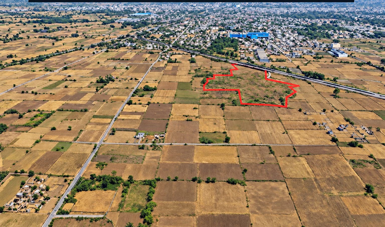
For sale · Gurugram district, Haryana
7.28 acres inSector 10, Pataudi
A single contiguous land parcel on the NH-352W Gurugram–Pataudi–Rewari corridor, inside the Pataudi Final Development Plan 2031 zone, held with clear freehold title.
₹ 10 crore per acre·₹ 72.80 crore in total
Contiguous land parcel
7.28acres
NH-352W four-lane highway
45km
Pataudi land price growth, last 1 year
31%
Commercial CLU collector-rate multiplier
5×
Land area and highway length as stated in the investor proposal. Growth figures describe the Pataudi micro-market generally and are not a forecast for this parcel.
The opportunity
A well-timed entry into an emerging Haryana corridor
This is a land-banking and development opportunity for buyers who want exposure to the Gurugram–Pataudi–Rewari corridor before highway completion and CLU conversion reprice the market.
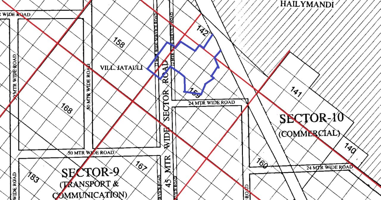
The parcel sits at Sector 10 (Jatauli Village), Pataudi, Gurugram District, Haryana 122413, on the NH-352W axis that connects the Dwarka Expressway through Pataudi to Rewari. Sector 10 corresponds to the Jatauli village area, which the Pataudi Final Development Plan 2031 places inside its designated development zones.
It is currently classified as agricultural land. Commercial, institutional or industrial use is unlocked through a CLU application to the Director, Town & Country Planning, Haryana — and under the 2026–27 collector rate framework a commercial conversion carries a 5× multiplier over the agricultural base rate, so entering at the agricultural classification is a real cost advantage.
The land is held within a company, so a buyer can acquire the company’s shares rather than execute a direct land conveyance — a structure that on a transaction of this size can save several crores in stamp duty.
Land records
The holding on the village map
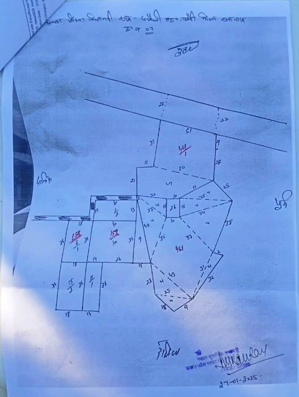
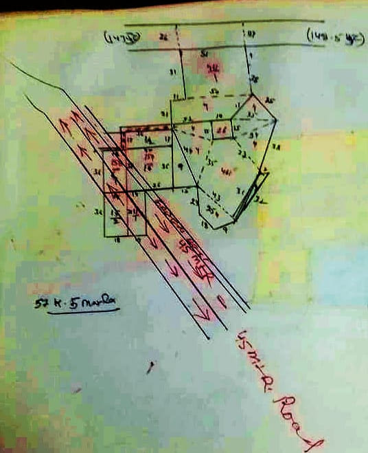
Two sketches from the land records: the field map of the holding, and the same map with the planned 45-metre road marked across it.
 View full size(opens in a new tab)
Aks shajra · field map
The holding on the village field map
- A copy of the field-wise village map (aks shajra kishtwar) for Jatauli, Tehsil Pataudi, District Gurugram, Hadbast No. 07.
- Shows each numbered field in the holding with its side measurements, and the road running along the northern boundary.
- North, south, east and west are marked in Hindi on the sheet.
- Stamped and signed, dated 27 January 2025.
 View full size(opens in a new tab)
Road alignment · overlay
The planned 45-metre road across the holding
- The same field map redrawn, with the 45-metre road hand-marked in red and labelled on the sheet.
- The road runs diagonally across the western fields of the holding, from north-west to south-east.
- It corresponds to the 45-metre-wide sector road shown on the Sector 10 plan drawing.
Both are photographed copies of hand-drawn revenue sketches, published for orientation only. They are not a survey. Boundaries, field numbers, the road alignment and how much of the holding the road affects should be confirmed through official demarcation and the land records in the due diligence pack.
Development potential
Several viable directions for a parcel this size
At 7.28 acres with road access on an emerging corridor, the land suits more than one use. Each depends on the relevant CLU permission.
Commercial / SCO
Warehousing & logistics
Institutional / mixed-use
The development use-cases above are subject to obtaining the relevant CLU (Change of Land Use) permission and applicable licences from the Director, Town & Country Planning, Haryana. No assured returns or guaranteed conversion timelines are represented or implied. Prospective investors should conduct independent legal and regulatory due diligence.
Location & connectivity
On the corridor that connects Gurugram to the industrial belt
NH-352W gives the corridor a direct freight and commuter route that bypasses the congested Delhi–Jaipur Expressway.
NH-352W (Gurugram–Pataudi–Rewari)
45 km four-lane national highway by NHAI. Over 70% of work complete, final completion targeted.Global City, Gurugram
1,000-acre mixed-use project on the Dwarka Expressway.KMP & Delhi–Mumbai Expressways
Regional freight connectivity across NCR, Haryana and Rajasthan.Manesar industrial belt
Maruti Suzuki, Reliance MET City and major logistics parks within practical distance.Haryana Orbital Rail Corridor
Proposed rail freight link connecting key industrial centres.Proposed. Timelines are set by the implementing authority.About 35 km from Rajiv Chowk, NH-48
Practical road distance to the core Gurugram business belt.
Government programmes
Four state programmes converging on the same belt
These are notified, documented programmes rather than speculation. What they mean for any individual parcel is a matter for your own diligence.
HSVP
HSVP Phase 1, Pataudi corridor
17,358 acres · 51 new sectors
Haryana Shehri Vikas Pradhikaran has identified the Pataudi–Farrukhnagar belt — sectors 88A, 89A, 95A and 95B — as one of four key high-growth targets in Gurugram district. HSVP has not developed new sectors in Gurgaon in over 20 years, making this the first government-led push into the Pataudi belt.
The proposal records that land in adjacent HSVP-notified zones has historically repriced 3–7× within five years of notification. Movement in other zones is not a forecast for this parcel.
HSIIDC
Pataudi Industrial Hub (Padma Scheme)
750 acres · 12 villages · 50,000+ jobs projected
Announced in March 2026 via the eBhoomi portal. The acquisition zone covers 12 villages in the Pataudi belt including Rampur, Janoula, Jori and Jatoala, which are adjacent to Sector 10.
The employment figure is the scheme's own projection, not a commitment.
Government of Haryana
eBhoomi voluntary land procurement
About 1.7 lakh acres across 71 towns
A state-wide drive under the eBhoomi portal through which landowners can offer land directly to the government, with transparent pricing and fast-track payment. Pataudi is explicitly named as a priority corridor. The Phase 1 deadline was extended to 30 June 2026, confirming active ongoing acquisition.
DTCP Haryana
Pataudi Final Development Plan 2031
Sector 10 / Jatauli village inside the development zone
The FDP 2031, notified by the Director, Town & Country Planning, Haryana, maps planned urban expansion of the Pataudi controlled area through 2031. Sector 10, which corresponds to the Jatauli village area, falls within the plan's designated development zones. Inclusion is formal government acknowledgement that the land is earmarked for planned urban growth.
Sourced from the Town & Country Planning Haryana and eBhoomi portals, as cited in the investor proposal. Government programmes change; verify current status directly with the relevant authority before you transact.
Market context
How the Pataudi micro-market has moved
- Last 1 year
- about 31%
- Last 3 years
- about 113%
Comparable 7–10 acre parcels in the immediate Pataudi area are listed in the ₹ 40–₹ 95 crore range, depending on road frontage, CLU status and amenity access.
Why the classification matters
Under the 2026–27 Haryana collector rate framework, a commercial CLU conversion attracts a 5× multiplier over the agricultural base rate, so entry at the agricultural classification is a cost advantage.
About the seller
Vijayi Yashvi Construction LLP is part of the KSD group of real estate entities, operating alongside KSD Buildtech Pvt. Ltd., a Gurugram-based real estate developer with projects across the Pataudi corridor.
- Yash Vihar, Sector 5, Pataudi
- DDJAY-approved plotted society
- HRERA registration
- Reg. No. 36 of 2020
- Licence
- No. 94 of 2017
Market figures are drawn from the June 2026 investor proposal and describe the Pataudi micro-market generally. Past appreciation is not a forecast, and no return is assured.
Explore further
Everything about this land, in one place
Prefer to ask directly? Send an enquiry and the team will come back with the due diligence pack. You can also use the assistant in the corner of the screen — it answers only from the details published on landinpataudi.in.
Ask us anything about this land
Send an enquiry and we will come back with the due diligence pack: title documents, land records, khasra details and site photographs. Site visits are arranged by appointment.